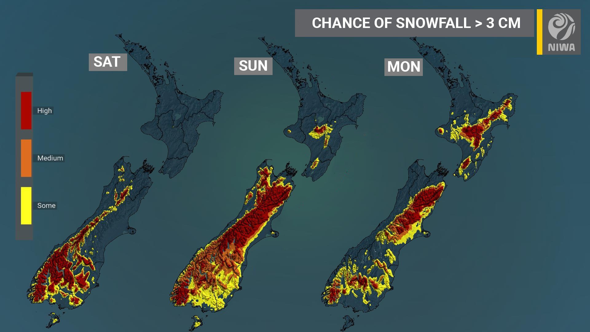
Chance of snow Graphic: Niwa
A significant cold snap is now locked-in for Canterbury tomorrow and Monday.
Blue Skies Weather & Climate Services forecaster Tony Truwinnard said heavy snow is now likely inland, and possibly on the western Plains, with light to moderate falls further east and some light snow likely for Christchurch city.
Metservice said rain or sleet developing in the morning, in Christchurch with snow lowering to 100 metres, then easing at night. Southerlies, strengthening towards evening.
Mr Truwinnard said “snow will already be falling inland at dawn tomorrow and heavy falls are likely during the morning, so there will be no time to react tomorrow – all preparation for this event needs to be completed today.”
Mr Truwinnard said for Mid and North Canterbury above 200m, expect snow to begin falling before midnight tonight and continue through the night.
“Heaviest falls will be in the morning tomorrow with snow slowly easing during the afternoon and evening. Snow should clear slowly from the south early Monday morning.”
Expect 10-20cm accumulations by dawn on Monday, with 20-30cm possible and falls of 30-50cm likely above 400m. Below 200m expect snow to push slowly across the Plains tomorrow night, reaching Christchurch and the coast around 3-4am. 1-5cm accumulations are likely on the Plains by dawn on Monday, with further brief light snow flurries till Monday afternoon.
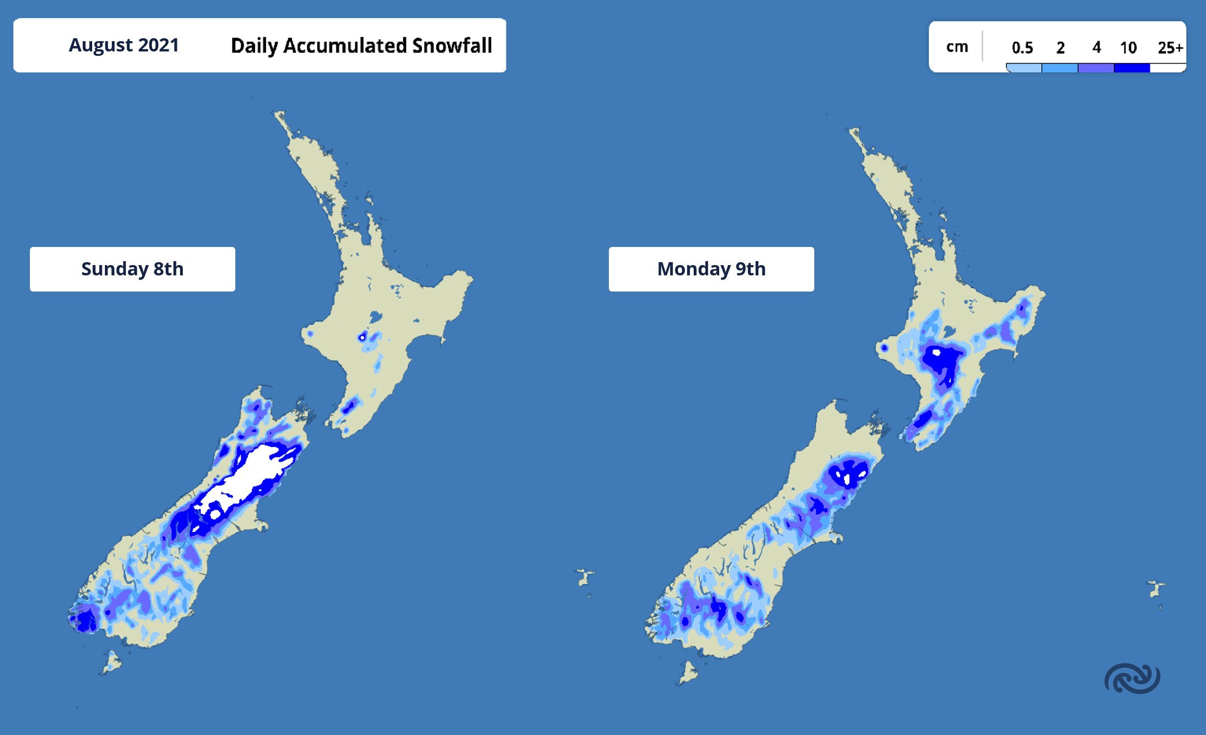
Graphic: Metservice
For South Canterbury above 200m expect snow to begin this evening and continue through tomorrow, with heaviest falls around dawn, and snow breaking to showers during the afternoon. Showers will clear early tomorrow night. Accumulations of 5-10cm are expected, with 10-20cm possible. Accumulations of 1-5cm are expected to very low levels through tomorrow.
Banks Peninsula may stay snow free through tomorrow with just rain during the day, but snow will lower to sea level later tomorrow night and frequent snow showers are likely through Monday till around 6pm. Expect 5-15cm above 200m, and 1-5cm to sea level by late Monday. Southerly winds will be strong on Monday with severe windchills
From tonight through Monday night will be a hazardous 48 hours for all stock, but newborn lambs and pregnant ewes especially. All stock will need extra care and attention, especially in areas with substantial accumulations.
For travellers:
Expect alpine passes to be affected by snow from late this evening . The quantity of snow expected may mean passes stay closed through Sunday. Roads in inland Canterbury above 200m (this includes the western Plains) are likely to experience snow accumulations. Roads on Banks Peninsula will also be affected from Sunday afternoon. For most of the Plains snow will be lighter and may not settle for long periods, but roads may be treacherous or briefly impassable at times. Christchurch city looks likely to experience light snow falls and accumulations of 1-5cm by early Monday morning, then further brief snow flurries till about 4-5pm Monday. This could cause significant localised disruption to traffic at times.
Queenstown airport may be affected by snow tonight. Christchurch airport may be affected by snow later tomorrow night. Cook Strait ferries may be affected by heavy swells and strong winds Sunday night and Monday. If you have plans to travel on Sunday or Monday be flexible and allow for possible disruption.
Elsewhere
Light to moderate snowfalls to 200m look likely in Southland and Otago later today and tonight, with light falls to sea level tomorrow. Expect heavy snow above 3-400m on the ranges of Nelson and Marlborough tomorrow night and Monday morning, sufficient to close higher roads and inland passes. Moderate snowfalls are looking likely in the central North Island tomorrow night and early Monday, and light falls to 2-300m on hills in the southern half of the island during Monday.